About Us

Follow along with us on our travels with our motor home. Minnesota is our home, but we go south for the winter. Yes, we are Snowbirds. We love traveling and want to share our experiences with you. This will be our third time traveling south to avoid the cold Minnesota winters. Our travels began in late October with the first destination of Concord, New Hampshire, and New Haven, Connecticut, to visit family before heading south and will eventually get to Arizona before returning to Minnesota in April.

Wednesday, February 29, 2012

Lake Mead National Recreation Area

Where to next?  Hmm...  We've been to Las Vegas a few times before so that was not at the top of our list.  After mulling it over a bit we decided to head to the Hoover Dam and Lake Mead National Recreation Area.  It was closer than we thought, just under an hour to get to our new spot.

While there are actual RV parks/campgrounds in the area we decided on this free area on the shore of Lake Mead, designated as "dispersed camping".   We'll probably be here a few days and drive around to see the sights.

Government Wash 


Tuesday, February 28, 2012

Pahrump and Shoshone

We're in Pahrump, Nevada, a small town just across the CA/NV border, close to Las Vegas, filled with RV Parks, Casinos, and Strip Clubs.   We're staying at Terrible's Lakeside Casino RV Resort for a few nights.

Our field trip today was to the even smaller town of Shoshone,California, about 20 miles away.  It's another old mining town trying to promote it's historic value.  Our first stop was at the Shoshone Museum/Visitor Center--open every day of the week except Tuesday (today).  This used to be the general store and gas station around 1920. Out front were some old gas pumps showing the price of $.44 per gallon, and an old Chevy with 1937 license plates.  They say they have skeletal remains of a mammoth in there.

Shoshone Museum and Visitor Center
 Since the Visitor Center was closed we walked next door to the Crowbar Cafe & Saloon for a sack.  The waitress gave us a paper showing the walking tour points of interest.

Drilling Contests were a popular part of the old "Amargosa Days."  Miners competed in "jackleg" drilling contests by drilling holes for dynamite in these rocks.  There were a few of these around town.

Rock with Drill Holes
The most interesting thing, and what drew us to this town, were the Dublin Caves.  During the 1900's through the 1960's many people famous in the history of Death Valley, including Death Valley Scotty, carved out dwellings in the clay embankments.  Some caves have split levels, stovepipes, and garages.  No one has lived in "Dublin Gulch" since 1970.

Some of the cave homes in Dublin Gulch
Then back to Pahrump for the rest of the day.


Monday, February 27, 2012

Death Valley

On the way to Death Valley we drove through this big valley.  No other vehicles, just us, and two Air Force jets frolicking at low altitudes.  One of them buzzed over us and nearly knocked me out of my chair.  I got my camera ready in case he did it again, and sure enough, he did.  Probably using us for fake target practice.


Death Valley is awesome.  There was no Internet service, or cell phone service, or TV, for the days we were there.  It was rough, but we managed.  Oh, there is so much to see and do there, a lot of driving, but lots to see.  And we did not see everything.  You really need a high profile, 4-wheel drive vehicle with tire chains, and at least a week to see it all.

We checked into our campground, only $6 a night for us... awesome.  We love not spending big money.  Of course, there was no electricity, or any other hook ups but we didn't mind that at all.

Stovepipe Wells Campground
The first thing we went to see was the nearby sand dunes.  We walked around for a few hours, it was cool.  There are other areas with more dunes, but these were close by.

Mesquite Flat Sand Dunes
Later, we drove up to see Scotty's Castle.  It was a private residence built in the 1920's, now open for tours.  The castle is interesting in itself, as it seems out of place in the middle of nowhere.  There is a strange and colorful story of how it came to be there, involving a con man, "Death Valley Scotty," who did not own the castle, and a Chicago millionaire, who became lifelong friends. I want to keep this blog a reasonable length, so you can read about it by clicking [here]

Scotty's Castle
 Behind the castle is what used to be a solar water heater.  Pretty high tech for 1920's.

Solar Water Heater
 Ubehebe Crater is a steam-explosion crater, created when water suddenly flashed to steam.  Half mile wide and 500 feet deep.
Ubehebe Crater
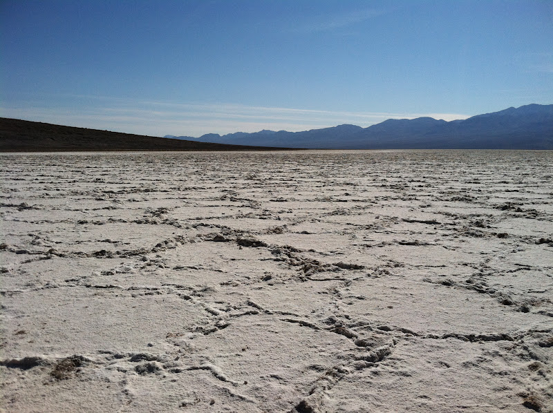
 Badwater Basin, 282 feet below sea level.  Death Valley is one of the hottest places on earth, often reaching  daytime temps of 120F/49C and night times and many nights don't drop below 100F/38C.  It's also the driest place in North America, getting less than two inches of rainfall a year.

Badwater Basin, 282 feet below sea level.
This area used to be a big lake, but has dried up and left nearly pure white salt crystal crust.  We walked out and around the salt flats.  It goes on for miles.
Salt Flats at Badwater Basin
 We hiked a lot in our time here.  Death Valley has many fascinating hiking trails.  Natural Bridge Canyon was one of our favorites.  Lots of different geographical curiosities.
Natural Bridge Canyon
Devil's Golf Course--gnarled crystalline salt spires that look like a coral reef, remains of the last significant lake here, which evaporated 2,000 years ago.  There is no hiking trail, but you can walk about, but rather difficult, so we didn't walk far.
Devil's Golf Course
There are loads of minerals in the hills here.  Artist's Drive is a nine-mile drive that takes you in and around where the views are spectacular.  One stop along the way was particularly colorful.

Artist's Palette
Mosaic Canyon was a fascinating hike.  There were polished marble walls, it was beautiful.  And, of course, I forgot my camera!  So Bernie took the pics with his little flip phone.  Good thing, or we would have had to drive back to the RV to get mine!  The pics are ok, but missing some color.

Mosaic Canyon
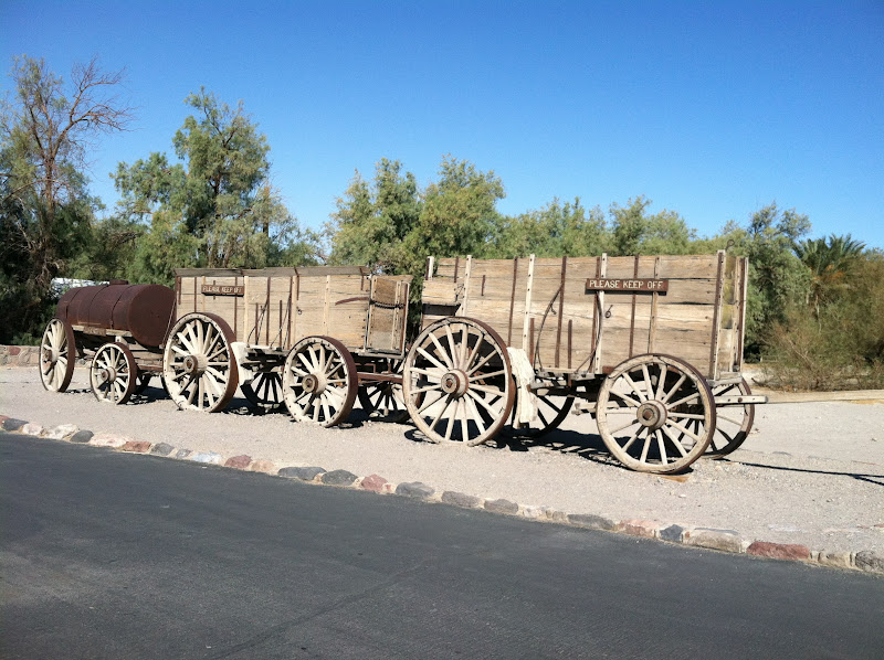
Borax has a huge presence here.  Prospectors found borax in 1881, and the Harmony Borax Works began to process ore in 1883.  They used 20-mule teams to haul borax 165 miles to the railroad town of Mojave.  The teams averaged two miles an hour and took about 10 days to get there.  There is a museum here that has loads of information and artifacts from that time period.

20 Mule Team Wagon Train
The mule team wagon train was eventually replaced by a steam tractor and new ore wagons which in turn were replaced by a railroad.

Old Dinah
Steam Train
Gas is very expensive inside Death Valley National Park.  Average prices in California were more like $3.85, we were shocked to see this here.  Remember, if you go there, fill up first!

OMG!
We only saw about half of what Death Valley has to offer.  There are many miles of back roads, many sights to see that can only be reached by the back roads, and hiking beyond that.  Our little Saturn car was not up to the task.  You can rent a jeep for a small fortune, but we thought we should move on.  Hopefully, we will return some day to see more cool stuff.


Thursday, February 23, 2012

Death Valley

Heading to Death Valley today. It's pretty remote, so if you don't hear from me in a few days that's why.

Wednesday, February 22, 2012

Back to Bakersfield

I think we've gone about as far north as we're going to go this winter.  California has more things to see and do, but we'll save those for next time.  We drove back to Bakersfield for tonight, staying in a different Walmart than we did last time.  It's early yet, but so far there are seven other RVs in the lot with us.  It's looking like a mini RV park.


Tuesday, February 21, 2012

Raisins and Big Trees

The RV park we are in is just across the street from the Sun-Maid Raisins processing plant.  So, naturally, we had to go see.  They have a very nice store next to the office.  We saw a little video and made some purchases.  Most of the grapes grown in this area are for raisins, not wine.  This part of California claims to be the raisin capitol of the world.

Sun-Maid Headquarters
The grapes are picked in September,
and left to "sun dry"
for two to three weeks.
 A few miles away you can find the World's Largest California Dancing Raisin in the lobby of the Spike & Rail restaurant in Selma, California.  We went for a late breakfast.  Nice place, good food.

Worlds Largest California Dancing Raisin
 Next, on to see some big trees.  Today we went in to Sequoia National Park at a different entrance.  There are still closed roads, so we couldn't see everything we wanted to see, but we were able to see some of the big Sequoia trees. 
I spotted these in a hallway at the Visitor Center.
 We are in the snow again.  At an elevation of around 6,000 feet.  My goodness, there are some big tees here!  You have to see them to really appreciate the size, photos just don't do it.
Trees dwarf the camper below.
Please stay on the trail. :(
Bernie inside a fallen Sequoia tree.
See the tiny human sneaking up to the tree?  
Grant Tree is the second largest tree in the world.
We were unable to see the largest one because
of the closed roads.
Awesome views at 7,000 feet

Monday, February 20, 2012

Sequoia National Park

We knew visiting Sequoia National Park would be risky when we came this way, but thought we would take our chances anyway.  It was a bit of a drive from our RV to the entrance to the park but that's ok.  The drive there was nice, lined with orchards of oranges almost all the way, and we enjoyed the view of the mountains of Sequoia National Park in the distance.

The morning drive
There are not a lot of roads in the park and the ones that are there are narrow winding mountain roads.  We learned that there was road construction about 15 miles in and beyond that it is required to have chains on your car tires because of snow in the higher elevations.  This is something that can change daily, so perhaps tomorrow or the next day we can go without the chains.  We were not interested in doing the tire chains thing so we just drove up to where the construction began and parked there and hiked around.  The weather was cool, but not too bad for a hike. We walked down a road that led to a campground that was closed for the season, so there was no traffic allowed on it.  
  
Bernie thinks he can do some rock climbing.
There were some nice views.
Tunnel Rock is a huge granite boulder beneath which the CCC (Civilian Conservation Corps - a public work relief program during the Great Depression) dug a tunnel for the roadway in 1938.  The road now bypasses the "tunnel" but visitors can walk beneath it.

Tunnel Rock
On the way back to the RV we chose to take the back roads.  We drove past miles of groves of oranges and plums and olives and lemons and grapefruits, stopping to take a picture of the blooming trees.

Trees in bloom (Almonds?)
We did not see a Sequoia tree.

Sunday, February 19, 2012

Kingsburg, CA

Before we left Bakersfield we went to get a picture of this shoe-shaped shoe repair shop.  It was built in 1947.  It's had a few owners over time, but you can still get your shoes fixed here.

Big Shoe Repair
We went 90 miles north to a Passport America RV park not too far from the entrances to Sequoia National Park.  We'll go check that out tomorrow.  After we got settled we drove to the nearby town of Kingsburg.  To keep up with the town's Swedish history they have most retail businesses designed in Swedish architecture.  They even have a Swedish coffee pot water tower.

Kingsburg, CA
 The drive to Kingsburg was mainly flat agriculture land.  We saw many fields of grape vines, oranges, nectarines, peaches, cherries, walnuts, pistachios, almonds.  They signed the fields!!  I loved that!  Also, Kingsburg is where the headquarters for Sunmaid Raisins is, perhaps we will explore that tomorrow before we go look at the big trees.

DelMonte
 Also nearby is a tourist stop, Bravo Cheese Shoppe.  The usual souvenir place with nuts and dried fruits, jams and jellies, etc. loads of antiques, and a restaurant, but with lots of character.  You can also look through a glass window and watch them make cheese in the next room, but not today (Sunday).  This is also California Dairy country, we did see several large animal factories, with thousands of milk cows.

Tree House at Bravo Farms
Bravo Farms
Hello

Saturday, February 18, 2012

20 Mule Team Borax

Remember 20 Mule Team Borax?  On our way to Sequoia National Forest we went through a little town of Boron, CA, and saw this mining operation off in the desert.  We found out that it really is where borax is mined.  

Borax Mine
In the 1880's the 20 mule teams used to haul borax from a mine in Death Valley to a railroad junction near this place.  Then in 1925 a huge deposit of borax was found here near the town of Boron.  Mining here replaced borax mining in Death Valley.

20 Mule Team
So there you have it, everything you didn't know you wanted to know about 20 Mule Team Borax.

Gas is going up!  And the tricky signing...the big prices are the "cash only" price... but look down at the little sign and you see the credit/debit card prices are quite a bit higher.

$4.15 cash price
$4.25 credit card price
There is an In-n-Out Burger joint behind us.  Since the press made a big deal about Barack Obama eating there, and we saw Rachel Ray make her version of it on her TV cooking show, we thought we should go have a burger and see what we've been missing.

In-n-Out is a California chain, with a few stores in Arizona, Utah, and Texas.  The menu is very simple:  hamburger, cheeseburger, or double-double, as well as fries and beverages, that's it.  They make a big deal about quality and freshness, nothing ever thawed, zapped or kept warm, they don't have any freezers, microwaves or heat lamps.  100% pure American beef, without additives.

In-n-Out Burger
We splurged and shared one $1.90 hamburger.
Hamburger
We drove about 200 miles today, stopping for the night in a Walmart parking lot in Bakersfield, CA.

Friday, February 17, 2012

Yucca Valley

It was nice having civilization and full hookups at the RV resort in Twentynine Palms but at $35 a night we thought we should move on.  Before we left we had a look around the town.  They have a lot of really nice murals on several of the downtown buildings.  This one is my favorite..it looked so real... a mural of a man painting a mural!  Love it!  Even the stone wall sections (see the bird?) on the left and on the right are part of the painting but look three dimensional, don't they?


Mural of a man painting a mural
It is expensive in California.  Gas is around $4 here, while only around $3.39 at home.

$4.05 credit card  /  $3.95 cash price

And when you buy any beverage at the store they charge you a CRV (California Redemption Value) fee.  But you can get that back when you turn in your bottles and cans at a redemption center
Sales tax can be any where from 7.25% to 9.25%, the highest in the country.

CRV fee $1.20 (taxable!)
7.750% Sales Tax
We are parked in a Walmart lot in Yucca Valley tonight, only about 15 miles from where we were last night, but, hey, it's free.  Tomorrow we will drive through more desert and mountains, no towns, to Sequoia National Park.  Don't be surprised if there is no blog tomorrow, we may not have Internet or cell phone service for a while again.


Thursday, February 16, 2012

Joshua Tree National Park

The last few days we have been at Joshua Tree National Park.  We should have known we would not have Internet service, or TV, or cell phone service, so that's why no blog from me for the last few days.  We saw and did so much and I took over 100 pictures the last few days, but this will be a condensed version.

Joshua Tree
This is a beautiful park, with desert, mountains, Joshua Tree forest, and spectacular views.  We did a lot of hiking to see geographical and historical sights.

Gold Mine


I wish the photographs could portray the awesomeness of what we saw. The picture below shows just a small portion of what we were looking at.  The haze in the valley is due to moisture, dust, and smog from Los Angeles.  This was a "clear" day.  If you look in the center of the picture, there is long ridge in the valley floor.  This is part of the San Andreas fault, the one that will probably break California off into the ocean some day, so they say.  1906 was the year of the big quake that did a lot of damage. We tried to drive down to see it closer, but there are no roads.  You can hire a jeep tour in Palm Springs if you want, but we didn't.  

San Andreas Fault Line
Down in the desert, not in the park, near the Salton Sea, a man by the name of  Leonard Knight, who discovered God after a life-altering event in 1967, created Salvation Mountain.  He has been building and painting on this since 1985, and just recently moved into a care facility.  Up until now he had been living in his painted-up truck here at Salvation Mountain.  We had to go see it.  Very interesting.

Salvation Mountain


An art truck near by
A popular thing to do in the desert is to go off-road.  We met a caravan of 10 Volkswagen off-road vehicles.  What fun!  


Back to the campground.  It's a beautiful place to camp, however, at the top of a mountain there are no services, no Internet, TV, electricity, water, or sewer dump, but for the $5 it cost us we didn't complain.  The weather had been cool which was perfect for all the hikes we had been doing.  But then we woke up to all this snow in the morning.  
Snow in the morning!  
 We had to wait until the Park Service cleared and re-opened the roads before we could leave the mountain and then we moved to a RV park in the town of Twentynine Palms near the entrance to Joshua Tree National Park.  It's a bit warmer here, and now we have civilization again.

Twentynine Palms Resort
Oh, I almost forgot to mention, one of the first things we saw when we got to the park was this poster about the killer bees in the area.  Fortunately we did not see any.

Killer Bees Alert